
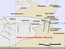
Remote communities along the Top End east coast including Ngukurr, Mataranka and Baruga are being pounded by intense winds and heavy rains as Cyclone Tiffany made landfall in the NT Wednesday morning, the Bureau of Meteorology said.
As of Wednesday afternoon, the Bureau said the cyclone is moving west at 29 kilometres per hour.
It is currently located over land, 30 kilometres west northwest of Ngukurr and 235 kilometres east of Katherine and is expected to continue moving westwards during today.
The BOM says damaging wind gusts and heavy rainfall remain possible over areas close to the system as it moves further west, with sustained winds of 75 km/h up to 100 km/h.
Cancelled warning zones include Alyangula to Port McArthur, Numbulwar, Ngukurr, and Port Roper.
Authorities have advised residents in the cancelled warning area to leave shelters where safe to do so.
While no major damages has been reported to buildings or infrastructure, people are also being reminded of to beware of debris, fallen power lines, and flooded roads.
“By Thursday, an upper trough will weaken the ridge. Steering becomes more uncertain at this point, with some guidance recurving the system to the southeast,” the BOM said.
Although the threat of the cyclone is easing, heavy rainfall, flooding and high winds are expected to remain causing hazards for the remainder of the week across the base of the Top End.
“Rivers right across the Top End will rise in response to this heavy rainfall,” the Bureau told the ABC. “The Top End community should be prepared for wet and windy conditions and flash flooding as we move into a vigorous active monsoon phase for the remainder of this week and into the weekend.”
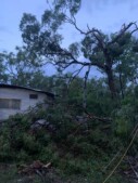
Photo of storm damage posted to Facebook.
Some residents affected by Cyclone Tiffany had shared updates in Facebook group “NT Pastoral Rainfall and Roads Updates” on the impact of the weather in their areas.
Laura Farmer living in Katherine shared photos and footage Tuesday night showing intense winds and rains battering tress.
Rachael Walters in the Roper Creek/Mataranka area also shared pictures and videos of uprooted trees and fallen branches.
NT Police assistant commissioner Janelle Tonkin said the current modelling indicated the Katherine River could reach “a moderate level”.
A flood watch has been issued for the North West and Carpentaria Coastal Rivers area.
Meanwhile, Darwin recorded what could be its coldest January day on record. The BOM said as of midday, the temperature was just 22.8 C, three degrees less than the previous coldest day in January 1989.

0 Comments