
UPDATED: The tropical low developing west of Darwin is expected to strengthen into a cyclone Friday night and could move east to the Top End over the weekend, the Bureau of Meteorology said, warning of torrential rains in northwestern areas.
“While the current track takes the system further toward the Kimberley Coast, there remains the possibility that the system could move to the east to the Top End,” BOM NT Manager Shenagh Gamble said in a press briefing Friday afternoon.
She said the weather system is expected to develop into a tropical cyclone Friday night or early Saturday morning and head south closer to the coast.
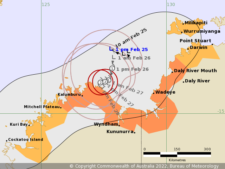
Cyclone warning map on Friday
“We are already experiencing wet and windy conditions in the western Top End and expect these conditions to continue over the weekend,” Ms Gamble said.
“Even if the risk of a cyclone reduces for some areas, these monsoonal conditions can be dangerous, particularly out on the water and with reduced visibility on the roads.”
Ms Gamble said many parts of the northwest Top End can expect to see heavy rainfall over the next three days with isolated totals of over 150mms.
“Significant rises in streams and creeks are expected leading to localized flooding in many areas along the northwest coast of the Northern Territory and this is expected to affect many roads over the weekend,” she said.
The Tropical Low is located in the Timor Sea about 330kms west of Darwin.
A cyclone warning for the category 2 storm remains from south of Dundee through to the WA border, including Wadeye.
The cyclone warning also extends to Mitchell Plateau to the WA/NT Border, including Wyndham and Kalumburu, not including Kununurra.
Communities within the warning area can expect to experience scales with gusts up to 100 kms per hour from tonight, BOM said.
A cyclone watch remains in place from Point Stuart to the WA/NT border, including the Tiwi Islands, Wadeye and Darwin and also Mitchell Plateau to Cockatoo Island.
BOM said that the large cyclone watch areas “reflects the area of uncertainty around the possible tracks that this system could take”.
“Communities within the watch area should monitor conditions on the Bureau website and app and via SecureNT to stay informed in case the situation changes,” Ms Gamble added.
A flood watch also continues for the NT northwest coast.
“The situation remains really active. So please stay up to date with warnings on our Bureau website and on the app,” she added.
EARLIER: The Top End is under a Cyclone Watch as a tropical low in the Timor Sea is expected to track towards the Territory, the Bureau of Meteorology said, with a moderate chance of turning into a tropical cyclone.
According to the BOM on Thursday afternoon, the tropical low is located 255 kms west of Darwin and 285 kms northeast of Kalumburu.
The monsoonal system is likely to be slow-moving over the next two days as it develops, the BOM said. It currently has sustained winds of 45 kms per hour with wind gusts up to 85 kms per hour, but is expected to intensify.
Current watch zones include Point Stuart to Kalumburu, including the Tiwi Islands, Darwin, Wadeye, and Wyndham.
The BOM says there remains the possibility of a track moving to the east over the Top End or a west southwest track towards Western Australia.
BOM NT manager Shenagh Gamble told a press conference that the exact path of the system remained uncertain as of 1pm Thursday.
“The future movement and development of this low is uncertain and several scenarios are possible,” Ms Gamble said.

“If it does develop into a cyclone and takes a more south-easterly track towards Darwin, the Darwin community could expect to experience gale force winds sometime over the weekend.”
“We encourage people to stay up to date with warnings on the Bureau website and our app.”
Weather officials also warn of gales with gusts up to 100 kms per hour that may develop in western parts of the Tiwi Islands overnight Friday.
It could possibly extend between Point Stuart and Wadeye on Saturday, or potentially west to Kalumburu if the low takes a more southerly track, the BOM said.
Heavy rainfall may develop over the Tiwi Islands and western parts of the Daly District during Friday and continue Saturday as the low intensifies.
If the system takes a more southwest track, then heavy rainfall could develop over northern parts of the Kimberley during Saturday, BOM added.
NT Emergency Services recommended that communities under watch zones prepare now for a cyclone, monitor conditions and stay informed.
If the low forms into a Cyclone it will be called Vernon.


0 Comments